PRODUCTS
CONTACT US
TEL: +86-532-85754589,85775618
FAX: E-Mail
E-MAIL: tlead.net@gmail.com; tlead.net@hotmail.com

Altimeter Compass
Keywords: barometric altimeter, FR510 altimeter, GPS altimeter, digital compass, handheld altimeter
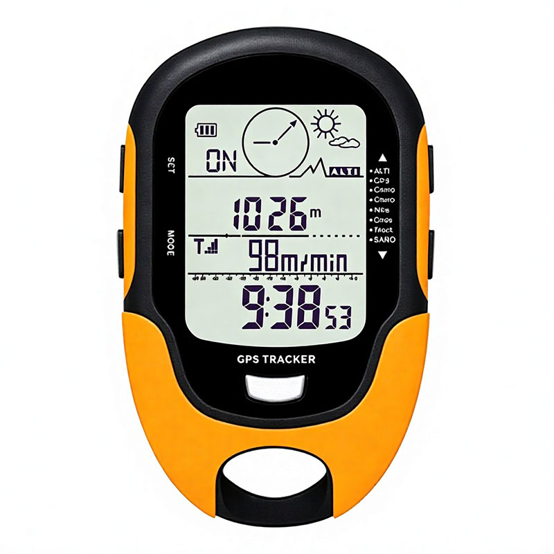
Handheld GPS altimeter and barometric compass with 24-hour altitude recording, weather forecast and IPX4 waterproofing.
The FR510 is a multifunctional handheld instrument for hiking, climbing, surveying and any activity where altitude, pressure and direction all matter. It uses GPS together with the Beidou navigation system for double-satellite positioning, and tracks speed, distance and up to nine routes while recording altitude data for 24 hours and rendering it as a chart.
Alongside the altimeter and barometer the unit packs a 16-direction digital compass, a thermometer and hygrometer with max / min history, a 12-to-24-hour weather forecast, a real-time clock with alarm, and a high-brightness LED torch. Altitude gain and loss are calculated automatically, altitude reminders can be set between 1 and 200 metres, and a target altitude can be programmed for the climb.
1. GPS and Beidou Positioning — double-satellite navigation provides speed, distance and up to nine groups of route tracking.
2. 24-Hour Altitude Recording — altitude data is logged over a full day and rendered as a chart, with gain and loss calculated automatically.
3. Altitude Reminder — a reminder can be set anywhere between 1 and 200 metres of gain or loss.
4. Target Altitude Setting — a target altitude can be programmed so progress is easy to judge.
5. History Max / Min Records — highest and lowest altitude, temperature and humidity are stored for later reference.
6. 24-Hour Pressure Trend — barometric pressure is charted over 24 hours, which helps predict changing conditions.
7. 16-Direction Digital Compass — a 360° compass with eight display directions and 1° resolution for navigation.
8. Thermometer and Hygrometer — temperature from −20 ℃ to 60 ℃ and humidity from 20 % to 95 %, with max / min history.
9. Weather Forecast — forecasts the next 12 to 24 hours across four states: sunny, slightly sunny, cloudy and rain.
10. Time, Date, Alarm and LED Torch — a 12/24-hour clock with alarm plus a high-brightness LED torch for night use.
11. USB Charging — recharges over USB, so no spare batteries are needed on a trip.
12. IPX4 Waterproof — protected against splashing water in rain or wet conditions.
| Model | FR510 |
| Product Name | Multifunctional Digital GPS Barometric Altimeter Compass |
| Altimeter Range | −2296 ft to 29500 ft (−700 m to 9000 m) |
| Altimeter Resolution | 1 m / 3 ft |
| Altimeter Mode | Sea level altitude / climbing altitude |
| Altitude History | Records altitude every 30 minutes; highest altitude during climbing recorded automatically |
| Altimeter Units | Metres and feet, switchable |
| Barometer Range | 300 hPa to 1100 hPa (8.8 to 32.6 inHg) |
| Barometer Resolution | 0.1 hPa |
| Barometer Units | Millibar and inHg, switchable |
| Thermometer Range | −20 ℃ to 60 ℃ (−4 ℉ to 140 ℉), resolution 1 ℃ / 1 ℉ |
| Hygrometer Range | 20 % – 95 % RH with max / min history |
| Compass | 360° with eight directions, resolution 1° |
| Weather Forecast | Next 12–24 hours; sunny, slightly sunny, cloudy, rain |
| Time and Date | 24 H or 12 H display, with alarm clock |
| LED Torch | High-light LED torch |
| Backlight | 5 seconds high-light LED backlight |
| Waterproof | IPX4 |
| Dimensions | 100 × 66 × 20 mm |
| Weight | 0.14 kg |
1. Hiking, trekking and mountaineering where altitude and direction must be tracked.
2. Climbing and trail running with target-altitude and altitude-gain reminders.
3. Surveying, forestry and field work requiring barometric pressure records.
4. Fishing, camping and other outdoor activities where weather trends matter.